-
October 2024
-
Consultant appointed for preliminary engagement workshops
Element Advisory and Align Strategy+Projects appointed
The City of Melville is reviewing the planning framework that guides the future of the Booragoon City Centre. For more than a decade, the Melville City Centre Structure Plan has shaped how the City Centre has developed. This review will transition the existing plan to the Booragoon Precinct Structure Plan (BPSP), which will set the long-term direction for land use, built form, transport, public spaces and infrastructure, informed by evidence and community input.
The Booragoon (Melville City Centre) Precinct Structure Plan is subject to a statutory 10-year review. The Western Australian Planning Commission has approved a two-year extension, allowing the review to be completed by 2027.
The purpose of the review is to ensure that future planning for the precinct:
- Aligns with State and local planning policies
- Supports sustainability and community wellbeing
- Responds to transport, infrastructure and public space needs
- Encourages economic activity and employment
- Accommodates population change
- Ensures development is appropriately scaled and integrated with its surroundings.
As part of this work, the City will also prepare a Master Plan for City-owned land within the precinct, focusing on best-use outcomes and long-term community benefit.
External consultants Element Advisory and Align Strategy+Projects have been appointed to support the planning and engagement process.
Location
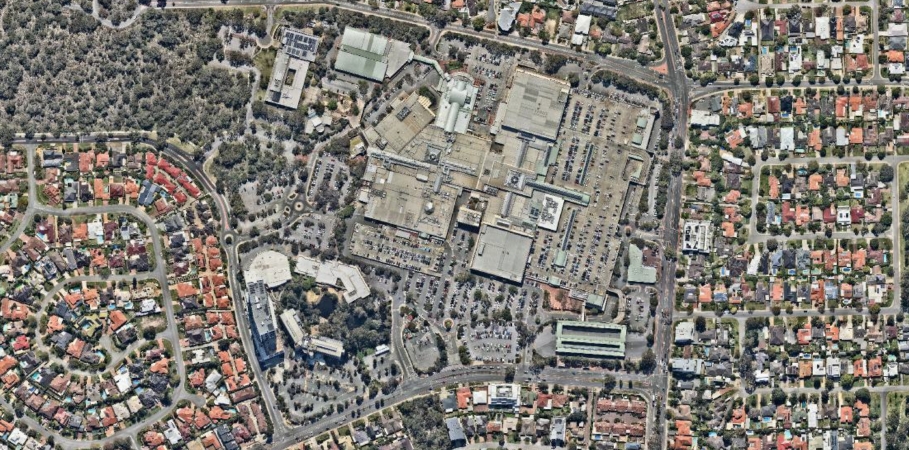
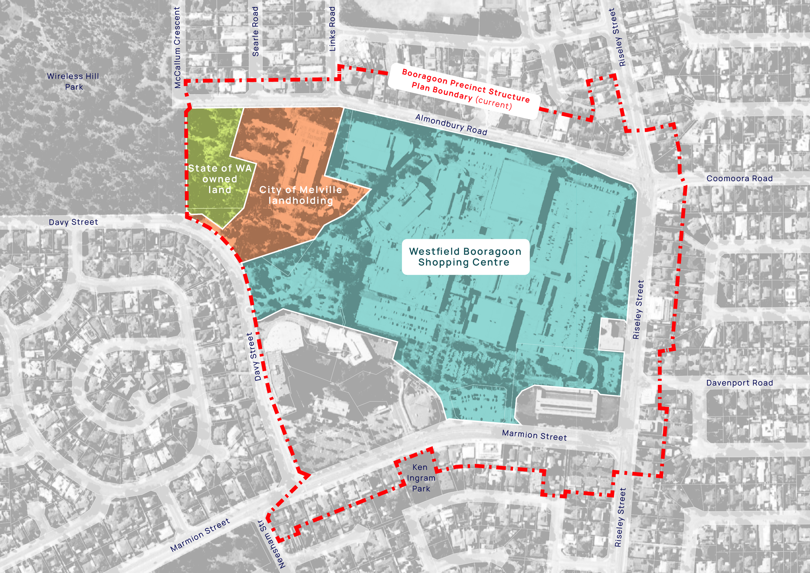
The Booragoon precinct boundary is located between Marmion Street North, Riseley Street, Davy Street North and Almondbury Road in Booragoon.
What's happening now
At the Ordinary Meeting of Council on Tuesday, 17 February 2026, Council noted the preliminary engagement findings and confirmed the review will be evidence-led and design-focused, with Elected Member workshops to occur before any draft plans are released for public consultation.
The City will begin early discussions with State planning stakeholders to explore acceptable density scenarios. Future engagement materials will outline potential impacts, including traffic, parking, housing diversity and tree canopy, alongside updated tree protection and planting considerations.
Engagement opportunities
To prepare for the formal review, the City completed a preliminary engagement phase in February 2025. This early engagement was designed to understand opportunities, concerns and expectations before any draft plans are prepared.
Engagement activities included targeted workshops with:
- Community members (residents, landowners, businesses and visitors)
- Commercial landowners
- State Government agencies
- Elected Members
- The City’s Senior Leadership Team.
Feedback from this phase is summarised in the Engagement Outcomes Report and will inform the next stage of work.
Preliminary Community Engagement and Outcomes Report
Further community and stakeholder engagement will occur as the review progresses. To receive updates, follow this engagement page to receive notifications directly to your email.
Project FAQs
The current plan for the Melville City Centre was set to expire in October 2025. However, a request has been submitted to the Department of Planning, Lands and Heritage (DPLH) to extend the plan for an additional two years, allowing time for the necessary review process. Under planning regulations, these types of plans are required to be reviewed every 10 years.
Recent development proposals in the Booragoon precinct highlight the need for an up-to-date planning framework to guide informed decisions on future developments. Notably, an expansion of Westfield Booragoon was approved in February 2023, which includes retail growth, additional car parking, and public realm enhancements.
In addition, we have committed to developing a new library and cultural centre within this precinct.
In Western Australia, a Precinct Structure Plan (also known as an Activity Centre Plan - ACP, or Structure Plan) plays a critical role in shaping the development of mixed-use areas such as city centres, town centres, and other hubs of activity.
These plans help ensure that development within these centres occurs in a coordinated, sustainable and strategic manner. They set the framework for managing growth and development, ensuring it aligns with the strategic objectives and community needs over time.
The Plan must:
- Comply with state and local planning policies
- Promote sustainability
- Support community well-being
- Address transport, infrastructure, and public space needs
- Encourage economic growth
- Accommodate population changes
- Ensure development is appropriately scaled and integrated with its surroundings.
The Booragoon Precinct (previously known as the Melville City Centre) is classified as a ‘Secondary Centre’ under the State Planning Framework.
A Secondary Centre is multi-purpose, offering a diversity of uses, services, facilities and employment opportunities. They perform an important role in the regional economy and provide essential (day-to-day) services to their residential catchments (typically up to 150,000 people). They have a medium to high density urban area within the core, with activated pedestrian-friendly street frontages and public spaces. This is typically surrounded by low to mid-rise buildings, pedestrian scale streets and landscaped character.
Other examples of secondary centres in WA include Claremont, Cockburn, Karrinyup, Leederville, Kwinana, Subiaco, Victoria Park and Whitfords.
The Booragoon Precinct boundary, as shown on the map below, is located between Marmion Street North, Riseley Street, Davy Street North and Almonbury Road in Booragoon.

The review has commenced, and at this stage no individual has been appointed by the City to lead its development.
The final decision for the Plan rests with the Western Australian Planning Commission (WAPC) in consultation with the City and relevant State agencies.
The final decision maker for the Master Plan of the City’s landholdings is the City of Melville.
The preliminary engagement for the Booragoon PSP was undertaken as a separate project from the LPS6 review. LPS6 applies to the entire City of Melville and proposed changes to R-coding near, but not within, the Booragoon PSP boundary. While LPS6 includes density coding for the centre, it relies on the Melville City Centre Structure Plan to guide detailed development controls within that area. The formal review of the Booragoon PSP, which will update the Structure Plan, will separately address development controls for the precinct. Although these processes are managed independently, related issues were acknowledged and considered during the preliminary engagement. Further information is available on the LPS6 engagement page.
Contact us
If you require any further information, please contact us.
| Strategic Planning Team | Paula Venter |
|---|---|
| Phone | 08 9364 0666 |
Workshop FAQs
Element Advisory and Align Strategy+Projects were appointed to undertake preliminary stakeholder engagement ahead of the formal review process.
This engagement involved identified key stakeholders and sought to understand stakeholder perspectives on the Booragoon Precinct, with the aim of informing future considerations and the engagement approach for the comprehensive review of the Booragoon Precinct Structure Plan and the Master Plan for the City’s landholdings.
The preliminary engagement workshop held in February 2025 sought to understand how community members and stakeholders would like to be involved throughout the review process.
This feedback helped ensure community expectations and aspirations were considered as early as possible in the review.
A structure plan review typically involves a comprehensive, multi-stage program of community and stakeholder engagement to help shape a shared vision and future planning controls for the area.
There will be multiple opportunities for the community to get involved throughout the review process.
While the details of the engagement approach are still being finalised, the best way to stay informed is to select ‘Follow Engagement’ at the top of this page.
Participants attended a single workshop in early February 2025, where they were provided with background information on the Booragoon Precinct and the upcoming Structure Plan review process.
During the workshop, participants took part in facilitated activities to explore opportunities and constraints within the area, helping to inform early considerations for the Structure Plan review. Participants also shared their perspectives on how the community and key stakeholders could be involved throughout the broader review process.
The appointment of participants for the community workshop was managed through an Expression of Interest (EOI) nomination and selection process. All nominees were assessed against defined criteria to support broad representation of stakeholder interests within and surrounding the Booragoon Precinct.
Invited participants were selected by the appointed consultants, Element Advisory and Align Strategy+Projects, through a blind assessment process using de-identified information to help achieve a diverse mix of demographics, perspectives and community interests.
Participation was voluntary and included residents (both local and from the wider area), business owners, workers, and other interested community members.
Select the ‘Follow Engagement’ button at the top of this page to receive email updates about project outcomes and future opportunities to get involved.
Timeline
-
4 December 2024 - 8 January 2025
-
Preliminary Engagement Workshop EOI nomination period (five weeks)
Nominate your interest to attend a Preliminary Engagement Workshop
-
February 2025
-
Preliminary Engagement Workshops
Workshops to identify opportunities, ideas, constraints - community, commercial and State agencies
-
April 2025
-
Findings under review
Consultants are gathering all the feedback and preparing a report on the findings
-
17 February 2026
-
Ordinary Meeting of Council
Council noted the preliminary engagement findings and confirmed the review will be evidence-led and design-focused
Was this page helpful?