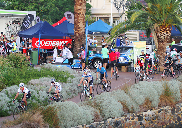
The City of Melville has a TravelSmart initiative, which aims to reduce our reliance on cars and making smart choices about other forms of transport.
Almost everyone is involved in some form of travel everyday, whether it is travelling to work, school, shops, to entertainment or to sport, so we can all play a part in reducing greenhouse gas emissions and improving the quality of life for ourselves and out communities.
To find out more about the City of Melville transport initiatives, click on the tabs below.
As well as the City's initiatives, the Western Australian Department of Transport provides maps to help you be travelsmart and maintain an active lifestyle, showing various routes via various transport methods to local facilities such as supermarkets, dog exercise areas, public toilets, skate parks, playgrounds and post boxes - Check it out at Map your Move Melville.
View the Walk and Ride Plan
In late 2021 and 2022 we invited the community to share their feedback about their experiences walking and riding around the City of Melville via an interactive map, online survey and in person workshop. The information shared by the community, as well as other stakeholder feedback, has been used to inform the create the finalised Walk & Ride Melville Plan.View the Walk & Ride Plan Summary
View the Walk & Ride Plan

Don't Drink and Drive
Check out our animated video Social Sally Gets Silly. It doesn't take much to put you over the limit.
Lower your Standards - Stay under 0.05.
More information at www.rsc.wa.gov.au
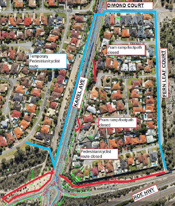
Karel Avenue Project Principal Shared Path (PSP) Realignment
Construction activity has commenced in various locations across the Karel Avenue Upgrade Project, with the impact on road users, pedestrians, cyclists and the surrounding community expected to be limited.
To allow further construction works to commence, a minor Principal Shared Path (PSP) detour is required for users north of the Karel Avenue and Roe Highway bridge.
Detour for cyclists and pedestrians
- Temporary closure of PSP north of Karel Avenue and Roe Highway bridge
- PSP users will be detoured via Karel Avenue northbound to Dimond Court and through to Fern Leaf Court (see blue path on map below).
- For younger riders and pedestrians, access across Karel Avenue is available north at the controlled intersection (traffic lights) on Farrington Road.
- Karel Avenue is still open to cyclists, however, for rider safety please utilise the PSP whenever available.
The detour will be in place for an estimated 10 months.
More information
If you have any questions or concerns, please email Main Roads or call 138 138. For more information, refer to Main Roads Project Update.
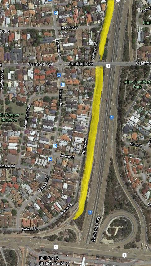
Kwinana Freeway: Principal Shared Path (PSP) Construction and Upgrade - Leach Highway to Mount Henry Bridge
- This is a Main Roads WA project.
- A new and upgraded Principle Shared Path (PSP) is being constructed on the western side of the Kwinana Freeway from Bull Creek to Mount Henry Bridge (as shown in the image).
- Construction will start in mid-February 2021 and finish in late 2021.
- Works will involve removing the existing brick wall along Selway Road, building a 4m wide red asphalt path and then constructing a noise wall between the path and the freeway.
- The path will connect to the existing PSP north of Bull Creek Train Station following the Freeway, diving under Cranford Road and under the north-bound slip lane and then connecting to the existing path which will be upgraded to the Mount Henry Bridge.
- Main Roads WA has identified a detour for existing path users along Bateman Road.
Please see Main Roads WA for more information.
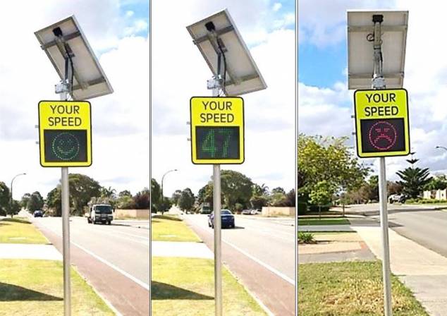
Your Everyday Speed (YES) Signs
Speeding drivers impact on how residents use the street and they have serious implications for road safety.
A study of Western Australian car crashes showed that 32% of pedestrians killed would have survived if the driver was driving just five kilometres an hour slower, and one person in 10 would not have not been hit at all! (Source: Office of Road Safety)
The ‘Your Everyday Speed’ (YES) signs have inbuilt radar allowing the sign to display each driver’s individual speed, a corresponding smiley / frowny face and a reminder of the posted speed.
Drivers can be seen to be reducing their speed to match the speed limit while the signs are in operation.
The YES signs will be rotated around our ‘speedier’ streets and the footings will stay in place to be re-used as needed.
E-scooter and E-skateboard rules and regulations in WA
The Department of Transport would like to remind the community of the current rules and regulations around the use of electric scooters (e-scooters).
Unlike e-bikes, many e-scooters and e-skateboards available for purchase are illegal to use on public roads and paths in WA. Given the speed at which they can travel and the power of their motors, they can only be used on private property, with riders strongly urged to wear a helmet.
E-scooters which are compliant with the current WA road traffic regulations can be legally ridden on paths and low speed public roads. Compliant e-scooters have a maximum power output of no more than 200 watts and they cannot travel more than 10 km/h on level ground.
Riders of e-scooters that are compliant with the relevant power output and speed regulations must also adhere to the following rules under the Road Traffic Code 2000:
- Riders must wear a helmet;
- Riders are permitted on footpaths and shared paths, so long as the rider keeps left and gives way to pedestrians;
- Riders cannot ride on roads with a speed limit exceeding 50 km/h;
- Riders cannot ride on roads with a dividing line or median strip;
- Riders cannot ride on one-way roads with more than one marked lane; and
- Riders cannot ride during the hours of darkness.
Mobility devices, including e-scooters and e-skateboards, continue to grow in popularity as people look for more innovative, efficient and sustainable ways to stay connected in cities and communities around the world.
In line with this community demand, as well as the potential of these devices to reduce car dependence and improve access to public transport, the National Transport Commission has been working with the States and Territories, to develop a regulatory framework which will allow for the safe and legal use of personal mobility devices in Australia.
The National Transport Commission’s recommendations regarding national regulations for these devices were agreed to by the majority of States and Territories, including WA. The Department of Transport will continue working with stakeholders, including the Road Safety Commission, to determine how best to modify State legislation to accommodate these recommendations.
The Department of Transport would like to take this opportunity to remind parents and riders that it is important to always wear a helmet, take care and ride safely.
As drivers, we are all responsible for the safety of our roads some safety messages for us to consider are:
- Wearing a seatbelt can protect us from severe injury in a collision.
- Don’t drink and drive. Driving under the influence turns me into a lethal weapon. If I drink-drive, I could harm myself and others.
- No mobile phone while driving - they distract me and lead me to hit someone or something.
- Slowing down, taking my time. I will keep to the limit and remember that the faster I drive, the harder I hit.
- Taking a break. Resting for at least 15 minutes every two hours will help me stay alert.
- Swapping drivers when tired. Driving tired can cause my thoughts to wander or cause me to fall to sleep at the wheel.
- Restraining children correctly. Choosing appropriate restraints can keep children and babies safe. I should check for damage or wear.
- Keeping my distance. I will keep at least two seconds between the time when the front bumper tyre of the car in front passes a stationary object and the front of my car reaches that object.
- Driving a safe vehicle. I will drive a vehicle that is roadworthy. When buying, I will look for high safety rating.
- Overtaking cyclists safely. I will give at least a distance of 1 metre when passing a cyclist.
- Keeping to the speed limit when overtaking. I will remember that it’s illegal to exceed the speed limit when overtaking.
- Being aware of pedestrians. I will be more alert around areas where pedestrians are likely to be.
Share the Space
Share the Space has been designed to raise awareness around sharing paths, roads and shared spaces by using the key messages of:
- Inspiring compassion for others, particularly seniors and those with various ability.
- Improving road safety through raising awareness of behaviour in shared spaces and of the people that use them.
- Reinforcing that safety is a shared responsibility.
For more information about the campaign, visit the Eastern Metropolitan Regional Council (EMRC) website.
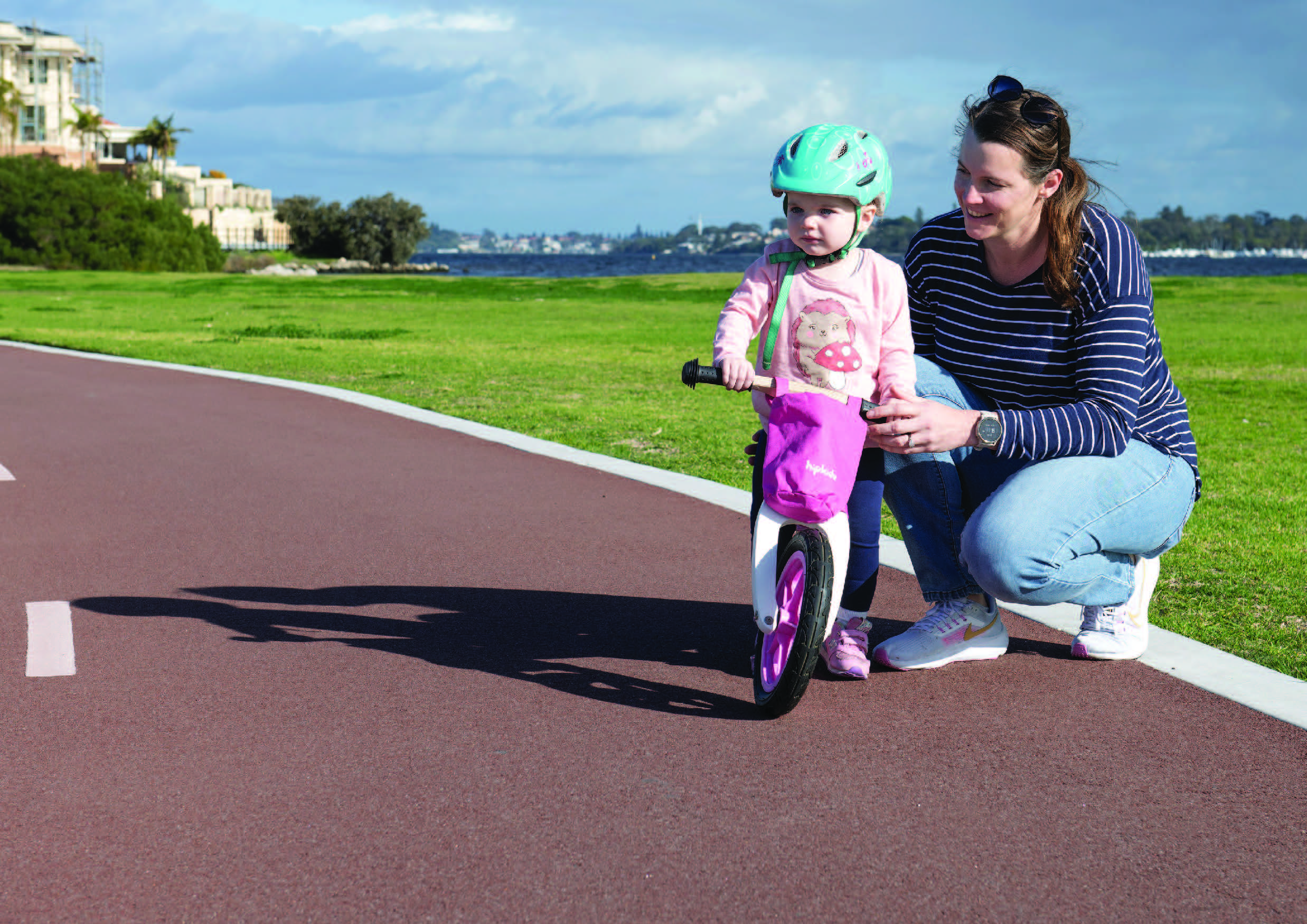
Road Safety for Children
Educating our children about road safety is also vital - for their safety today and the future safety of our City. The Constable Care Safety School is a best-practice excursion destination for children aged 4 - 11 years.
Hooning
Hooning is antisocial behaviour - it is both reckless and dangerous. Contact the police on 131 444 or refer to the WA Police Antisocial Behaviour webpage.
The City of Melville has a working group to promote TravelSmart activities, active travel modes, reduce the number and severity of road crashes in the City, and to encourage and promote safer use of our roads.
The working group plans community activities and actively participate in safety initiatives.
The group is made up of four volunteer community members, two Councillors and three City of Melville employees.
To find out more about the working group, contact the City's TravelSmart officer via email or phone 9364 0666.
Some testimonials from members of the working group:
“I am a local resident and I have three teenage sons. Keeping them safe on the road is my number one priority.”
“I am passionate about helping our suburb be more sustainable and even more special.”
“I care about improving the level of safety of all our road users as well as improving our urban amenity by improving and facilitating better transport in all its forms. I would like to bring some of my expertise to assist in improving my local community.”
City of Melville Bike Plan
The City of Melville Bike Plan 2012 sets out objectives for the continued development and promotion of cycling, which includes:
- Evaluating cycling and its associated infrastructure in the study area, along with the existing Bike Plan
- Consult with key stakeholders (Local Government, State Government and Local Community) regarding the future of cycling within the City of Melville
- Planning the expansion of the bicycle network for Melville
- Encourage and promote cycling
- Developing a prioritised schedule of works, along with high level preliminary costing
- Developing a maintenance schedule for the protection of new and existing assets
New cycleways and bike paths
Construction of a cycleway/bike path enables residents to access and enjoy the natural environment that surrounds their suburb. By integrating the cycleways into the infrastructure of the city, bike riding and walking will become the main means of transport and will help to create a healthier and cleaner community.
The following items are taken into consideration when requesting a new cycle facility:
- Traffic volumes
- Traffic/pedestrian conflicts
- Bus routes
- Road classification (distributor/local)
- Special considerations (eg: disability access)
- Places of congregation
- Safe routes to school
- Path requests
- Linking paths
If you would like to request a new footpath, please contact customer service.
Please note, cycling facilities on major roads such as Canning Highway, Leach Highway, and Kwinana Freeway is the responsibility of Main Roads WA.
For further information relating to Principle Shared path (PSP) view the Main Roads WA Smart Freeway website.
Cycling Rules and Penalties
As part of the City's TravelSmart initiatives, the City supports the State Goverenment's position for all cyclists to wear bike helmets.
The following penaties apply;
- Cyclists riding more than two abreast (with up to 1.5m between riders) $50 fine
- Not wearing a helmet $50 fine
- Failure to have at least one effective brake and working warning device (e.g. bell) $100 fine
- Failure to have correct lighting for visibility $100 fine
- Riding less than 2m behind a vehicle $100 fine
- Passing on the left of a vehicle that is turning left $100 fine
For more information on cyclists' rights and responsibilities on paths and roads, see the Department of Transport's Cycling Rules publication.
There are two main types of bus shelters within the CIty of Melville, and each of these is maintained by different organisations.
Shelters with no advertising are maintained by the City of Melville via a contractor which maintains and repairs damage.
We rely on you to report hazards such as broken glass, damaged panels etc so that we can clean the area and make it safe - please contact customer service to notify us.
If you notice a bus shelter that contains asbestos, please report it to the City and it will either be removed, replaced or repaired.
Traffic Calming
Traffic calming is a combination of physical measures aimed at slowing vehicle traffic on local roads, change driver behaviour and improve conditions for vulnerable road users such as pedestrians and cyclists.
Traffic calming measures include slow points, roundabouts, chicane, speed plateau, rubber speed cushions, raised intersection and road closures. The type used will vary depending on the actual problem and the characteristics of the site.
Potential installation of traffic calming measures considers:
- Speed and volume of traffic
- Reported crash history
- The hierarchy of the road in the road network
- Road design
- Land use and surrounding activities
- Terrain
To request traffic calming treatment please contact the City in writing by mail or email and include the following:
- Addressed to: Traffic Road Safety Coordinator
- Name
- Address
- Contact numbers
- Details of the problem that requires traffic calming
With traffic concerns regarding major roads: South Street, Leach Highway, Canning Highway and Kwinana Freeway, contact Main Roads WA.
Traffic Counts
The City of Melville undertakes traffic surveys to collect information on traffic volumes, speeds and types of vehicles on the road.
The use of traffic data recorders is to monitor traffic conditions on the City's road network and assist with forward planning for improvement works.
Speed assessments are usually undertaken mid-block on a length of road, with a number of counters set in place.
Vehicle types will be monitored.
To request traffic counts, please contact the City in writing by mail or email and include the following:
- Addressed to: Engineering Technical Officer
- Name
- Address
- Contact numbers
- Reason as to why Traffic Counts are required
With traffic concerns regarding major roads: South Street, Leach Highway, Canning Highway and Kwinana Freeway, contact Main Roads WA.
Black Spots
A black spot is a section of road (mid-block or intersection) where accidents occur on a regular basis. The City of Melville regularly monitors updated recorded crash data throughout the City to formulate solutions, apply for funding to implement the solution.
Most of the bike paths around the city are owned and maintained by the City of Melville. If you notice maintenance on these paths is required, please email us. We will send the request to the right area and get it fixed.
There are three types of bike paths in the city. The first is the Principle Shared Path (PSP) along Kwinana Freeway which is owned and maintained by Main Roads. Recreational Share Paths (RSPs) are typically 3 metres wide, red ashpalt and maintained by the City of Melville. You see these along the foreshore and Murdoch Drive.
The last type is our Pedasterian Access Ways (PAWs), owned and maintained by us. These are the paths along roads and between properties.